• International Leading Technologies Transfer Company Limited
  • Tiếng Việt Tiếng việt
  • English English
  • Youtube
Logo
  • Home
  • About us
  • Products
    • NON DESTRUCTIVE TESTING PRODUCTS
      • CONCRETE TESTING PRODUCTS
      • STEEL TESTING PRODUCTS
      • INSPECTION PRODUCTS FOR TRANSPORT ENGINEERING
    • STRUCTURE MONITORING PRODUCTS
    • DIGITAL SOLUTION IN SMART CITY AND INFRASTRUCTURE
      • TECHNICAL INFRASTRUCTURE FLOATING ON THE GROUND
      • UNDERGROUND TECHNICAL INFRASTRUCTURE
    • ANALYSIS & SIMULATION SOFTWARE
    • GEOLOGICAL AND ENVIRONMENT SURVEY
    • ANALYSIS, MEASUREMENT AND MONITORING PRODUCTS
  • Services
  • News
    • Activity News
    • Specialized News
  • Documents
  • Contact us
  • iltech.com.vn
  • ANALYSIS, MEASUREMENT AND MONITORING PRODUCTS

Unmanned surface vessels (USV)


Seafloor (USA) was established in 1999, specializing in providing unmanned survey ships (USVs) integrated with Sonar scanning technology used for hydrographic measurements, mapping underwater geographical features, surveying close to dangerous or difficult-to-reach waters. Up to now, Seafloor has designed many USV lines with diverse sizes and features, suitable for different requirements of customers. In addition, the company also developed more sensors and measuring devices to add to the USV in order to collect more data and increase accuracy in the survey process.

I. Application:

  • Collect data to map, determine the depth of the bottom of rivers, lakes, reservoirs, seas, hydroelectric dams...
  • Surveying and checking water quality in lakes, rivers, ports, wastewater treatment plants, complex water areas, difficult to access.

II. Features

  • Can be remotely controlled or self-driving thanks to the AutoNav ™ system.
  • Continuous operation for 8-12 hours.
  • Durable HDPE hull to withstand the elements of a wide range of aquatic environments.
  • There are many sonar modules to choose from.
  • Integrate a variety of sensors and transducers to collect a variety of data.

III. Products Range

  1. Hydro


- Typical Survey Speed: 3 kn, Top Speed 6kn

- Hull size: Length 1,16m x Width 0,21m

- Empty Hull Weight: 9,8 kg

- Payload: 15 kg

- Remote Range: 1km

- Motor: 2 x Brushless Thruster

- Battery Endurance: 8 Hours at Survey Speed

- Sonar Modules: Hydrolite-TM Echosounde, Hydrolite-DFX Echosounder, Side Scan, ADCP.

- Instrumentation Options: AutoNav ™ Control System, Built-In Telemetry System

                                                                              - Software: Hypack, Carlson, EPOCH, Leica, Sokkia, Topcon, and Trimble.
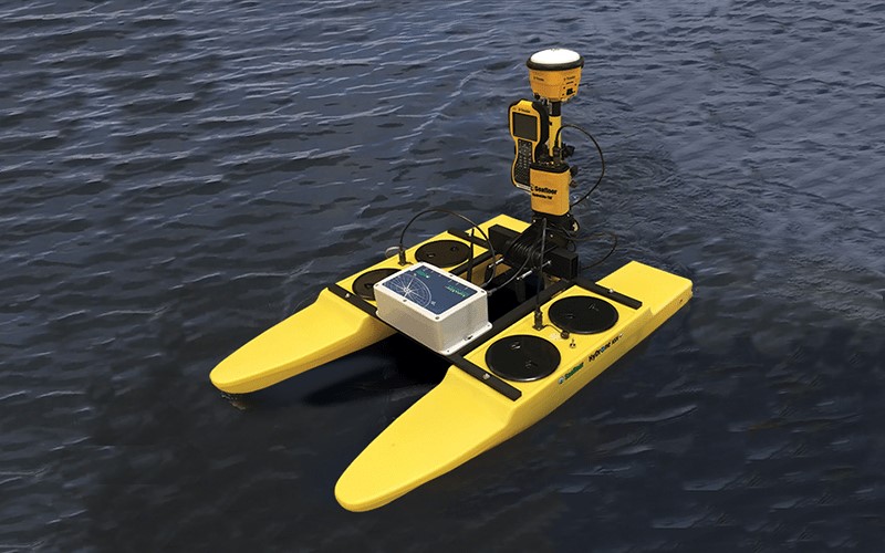
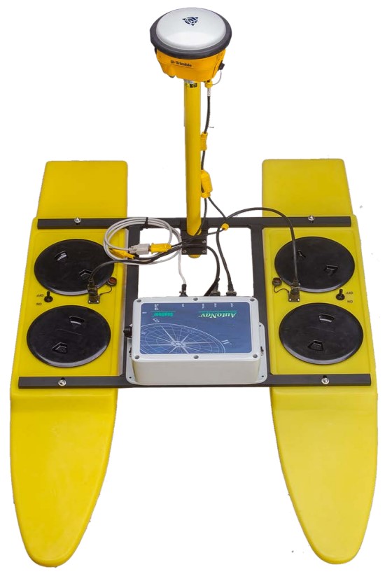
  1. TriDrone

​​- Typical Survey Speed:  3 kn, Top Speed 6kn

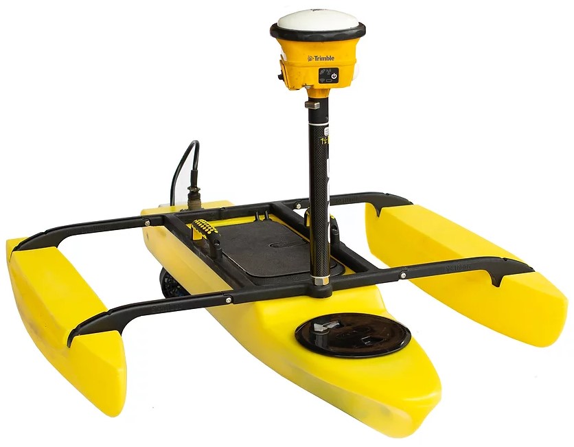
- Hull size: Length 1,22m x Width 0,86m

- Weight: 10 kg

- Remote Range: 1km

- Motor: 1 x Brushless thruster

- Battery Endurance: 8 Hours at Survey Speed

- GNSS: Takes a GNSS receiver and a data controller with supported software

- Sonar Modules: Hydrolite-TM Echosounde

 - Software: Trimble/Trimble Access.


  1. EchoBoat-160

- Typical Survey Speed:  3 kn, Top Speed 6kn

- Hull size: Length 1,68m x Width 0,8m

- Empty Hull Weight: 45 kg

- Payload: 30 kg

- Remote Range: 2km

- Motor: 2x Brushless DC Outdrive

- Battery Endurance: 8 Hours at Survey Speed

- Sonar Modules: Multibeam Echosounder, Singlebeam Echosounder, Side Scan, ADCP, Sub-bottom Profiler, Magnetometer

- Auxiliary Sensors: HD Thermal Camera, LiDAR

- Optional auxiliary equipment: SmartCast™ SVP/CTD Winch System, AutoNav ™ Control System, Computer with Wifi Bridge, EchoCart with LARS™ transport / launch & recovery system

-  Software: Compatible with most standard hydrographic data collection software.

  1. EchoBoat-24

​​- Typical Survey Speed:  3kn, Top Speed 5kn

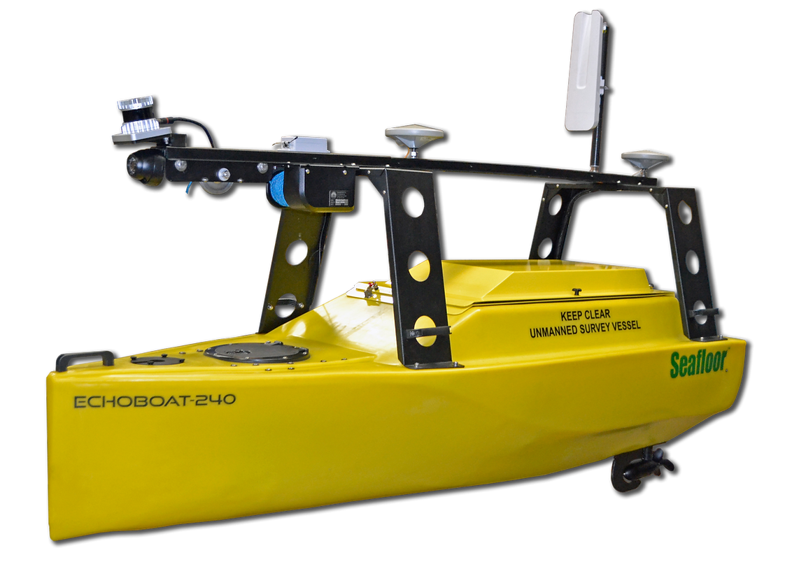
- Hull size: Length 2,4m x Width 0,9m

- Empty Hull Weight: 158,75 kg

- Payload: 90,7 kg

- Remote Range: 2km

- Motor: 2x Brushless DC Outdrive

- Battery Endurance: 8 Hours at Survey Speed

- Sonar Modules: Multibeam Echosounder, Singlebeam Echosounder, Side Scan, ADCP, Sub-bottom Profiler, Magnetometer

- Sensor: HD Thermal Camera, LiDA

  - Auxiliary Sensors: Sound Velocimeter, HD Thermal Camera, LiDAR

- Optional auxiliary equipment: Remote SVP Winch,  Wi-Fi Remote Desktop

                                                                           - Software: Compatible with most standard hydrographic data collection software.

  1. HydroCat-180

​- Typical Survey Speed:  3kn, Top Speed 6,9kn

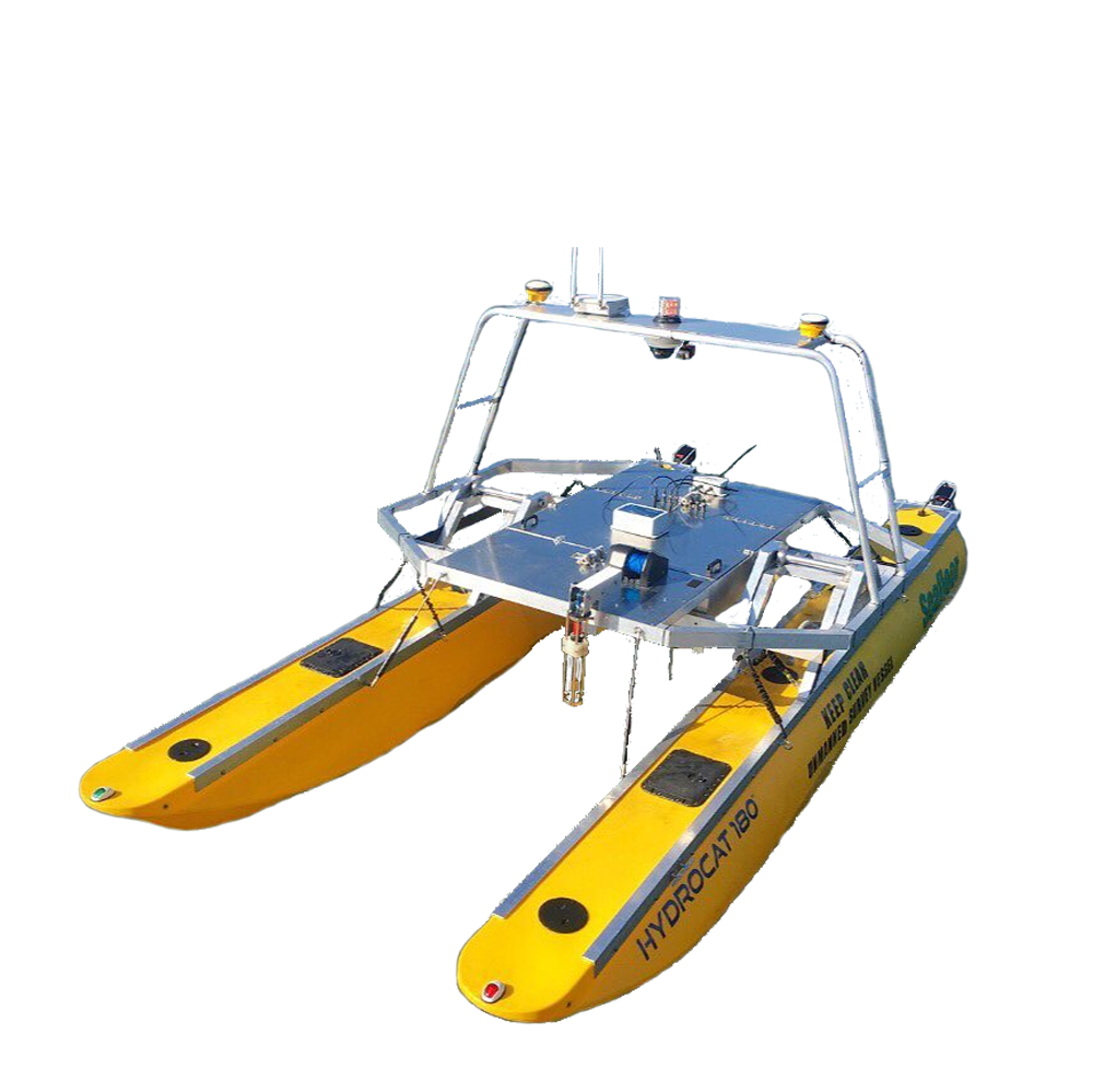
- Hull size: Length 5,5m x Width 2,5m x Height 2,75m

- Empty Hull Weight: 590 kg

- Payload: 318 kg

- Remote Range: 2km

- Motor: 2 x Electric Torqueedo™ 4 kW ~ 10 HP

- Battery Endurance: 8 Hours at Survey Speed

- Sonar Modules: Single or dual-head ultra high resolution multibeam sonar, Side Scan, ADCP/DVL, Sub-bottom Profiler, Magnetometer

- Auxiliary Sensors: Sound Velocity Profiling Winch, 180 - Degree HD Video Camera, LiDAR

- Available Auxiliary Equipment: Remote Controlled Profiling Winch, Onboard Industrial PC, Transport trailers

                                                                           - Software: Compatible with most standard hydrographic data collection software.

Tags: tàu tự hành tàu không người lái vận hành trên mặt nước tàu không người lái tàu nổi không người lái tàu khảo sát đại dương phương tiện không người lái khảo sát công trình biển công trình ngoài khơi công trình biển kiểm tra công trình ngoài khơi kiểm tra cảng biển điện gió ngoài khơi nghiên cứu hải dương sonar quét sườn máy quét sonar unmanned surface vehicle unmanned surface vessel hydrographic survey underwater construction survey side scan sonar multibeam sonar

Products

  • NON DESTRUCTIVE TESTING PRODUCTS
    • CONCRETE TESTING PRODUCTS
    • STEEL TESTING PRODUCTS
    • INSPECTION PRODUCTS FOR TRANSPORT ENGINEERING
  • STRUCTURE MONITORING PRODUCTS
  • DIGITAL SOLUTION IN SMART CITY AND INFRASTRUCTURE
    • TECHNICAL INFRASTRUCTURE FLOATING ON THE GROUND
    • UNDERGROUND TECHNICAL INFRASTRUCTURE
  • ANALYSIS & SIMULATION SOFTWARE
  • GEOLOGICAL AND ENVIRONMENT SURVEY
  • ANALYSIS, MEASUREMENT AND MONITORING PRODUCTS

New article news

ILTech_Completely transferring seismic equipment from Guralp (UK) ILTech_Completely transferring seismic equipment from Guralp (UK)
11/12/2024
ILTech completed the supply of seismic exploration equipment model X820S (24 channels) of M.A.E (Italia) ILTech completed the supply of seismic exploration equipment model X820S (24 channels) of M.A.E (Italia)
24/02/2024
Letter Of New Year Wishes For The Dragon 2024 Letter Of New Year Wishes For The Dragon 2024
03/02/2024
ILTech signed a contract to provide 11 sets of modern, high-tech equipment for geological - hydrological surveys and construction quality inspection ILTech signed a contract to provide 11 sets of modern, high-tech equipment for geological - hydrological surveys and construction quality inspection
03/02/2024
ILTech successfully handover Surface Roughness Measuring Equipment by International Roughness Index (IRI) ILTech successfully handover Surface Roughness Measuring Equipment by International Roughness Index (IRI)
20/01/2024

Documents

  • 02/07/2021: TCVN 12584:2019_Safety traffic equipment - Retroreflecting road studs - Techincal requirements and test methods
  • 02/07/2021: TCVN 12584:2019_Safety traffic equipment - Retroreflecting road studs - Techincal requirements and test methods
  • 02/07/2021: TCVN 8867:2011_Flexible pavement - standard test method for determination of elastic modulus of pavement structure using Benkelman beam
  • 02/07/2021: TCVN 8860-1: 2011_Asphalt Concrete – Test methods – Part 1: Determination of Marshall Stability and Pl astic Flow
  • 02/07/2021: TCVN 12585:2019_Safety traffic equipment- Delineator posts and retroreflectors - Technical requirements and test methods
  • 02/07/2021: TCVN 8819:2011_Specification for Construction of Hot Mix Asphalt Concrete Pavement and Acceptance
  • 02/07/2021: TCVN 11365:2016_Pavement Airport: Standard Test Method for Evaluation Pavement Classification Number (PCN) Using a Heavy-Falling Weight Deflectometer (HWD)
  • 02/07/2021: TCVN 10832:2015_Retroreflective pavement marking materials - Color - Specifications and test methods
View more

Gallery

  • Holiday!!!
  • Delivery and Training GALLERY
  • Exhibition, Seminar, Workshop...

Video

  • Underground Utilities Mapping for Smart Cities in Vietnam

    Underground Utilities Mapping for Smart Cities in Vietnam

  • Siêu âm cọc khoan nhồi tại tỉnh Quảng Ninh/ Cross-hole Sonic Logging model All-in One (Italia)

    Siêu âm cọc khoan nhồi tại tỉnh Quảng Ninh/ Cross-hole Sonic Logging model All-in One (Italia)

  • Discover Instantel's Micromate Monitoring Unit

    Discover Instantel's Micromate Monitoring Unit

  • Proteus Pipeline Crawler Inspection System

    Proteus Pipeline Crawler Inspection System

  • PCSS - Pavement Condition Survey System

    PCSS - Pavement Condition Survey System

About us

International Leading Technologies Transfer Company Limited

Hanoi Office: 3A Floor, Lidaco – Vinaconex 7 Building, 19 Dai Tu Road, Hoang Mai Dist, Hanoi, Vietnam

HCMC Office: 58/48 Nguyen Minh Hoang, Ward 12, Tan Binh District, HCMC

Tel: (84-24) 6027 8662

Email: info@iltech.com.vn/ inter-cooperation@iltech.com.vn

Hotline: (84) 914 382 786

© Company Theme. All Rights Reserved. Designed by ILTech