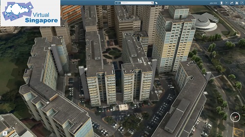
Virtual Singapore is a dynamic three-dimensional (3D) city model and collaborative data platform, including the 3D maps of Singapore. When completed, Virtual Singapore will be the authoritative 3D digital platform intended for use by the public, private, people and research sectors. It will enable users from different sectors to develop sophisticated tools and applications for test-bedding concepts and services, planning and decision-making, and research on technologies to solve emerging and complex challenges for Singapore.
This project is championed by the National Research Foundation (NRF), Prime Minister’s Office, Singapore, the Singapore Land Authority (SLA) and the Government Technology Agency of Singapore (GovTech). NRF will be leading the project development, whilst SLA will support with its 3D topographical mapping data and become the operator and owner when Virtual Singapore is completed. GovTech will provide expertise in information and communications technology and its management as required in the project. Other public agencies will participate in Virtual Singapore in various phases.
Virtual Singapore is an R&D programme initiated by the NRF at a cost of $73 million for the development of the platform as well as research into latest technologies and advanced tools over a period of five years. The platform is targeted to be ready by 2018 and will be deployed progressively. There are ongoing collaborations with government agencies, universities and partners to leverage Virtual Singapore for their modelling and simulation needs.
3D Modelling and Visualisation
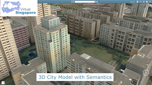
Virtual Singapore includes semantic 3D modelling, which comprises detailed information such as texture, material representation of geometrical objects; terrain attributes, for example, water bodies, vegetation, transportation infrastructure, etc. Models of buildings encode the geometry as well as the components of a facility, such as walls, floors, and ceilings, down to its fine details, as in the composition of granite, sand and stone in a building material.
Virtual Singapore will be developed based on geometric and image data collected from various public agencies, and will integrate different data sources to describe the city with the necessary dynamic data ontology. The 2D data and information co-ordinated through existing geospatial and non-geospatial platforms such as OneMap, People Hub, Business Hub etc. will enrich the 3D Singapore City Model. Advanced information and modelling technology will allow Virtual Singapore to be infused with different sources of static, dynamic and real-time city data and information e.g. demographics, movement, climate.
Capabilities of Virtual Singapore
Virtual Singapore offers four major capabilities, namely:
- Virtual Experimentation
Virtual Singapore can be used for virtual test-bedding or experimentation. For example, Virtual Singapore can be used to examine the coverage areas of 3G/4G networks, provide realistic visualisation of poor coverage areas, and highlight areas that can be improved on in the 3D city model.
- Virtual Test-Bedding
Virtual Singapore can be used as a test-bedding platform to validate the provision of services. For example, the 3D model of the new Sport hub with semantic information within the Virtual Singapore could be used to model and simulate crowd dispersion to establish evacuation procedures during an emergency.
- Planning and Decision-Making
With a rich data environment, Virtual Singapore is a holistic and integrated platform to develop analytical applications (i.e. Apps). For instance, an app could be developed to analyse transport flows and pedestrian movement patterns. Such applications would be useful in non-contiguous urban networks such as our parks and park connectors in Punggol.
- Research and Development
The rich data environment of Virtual Singapore, when made available to the research community with the necessary access rights, can allow researchers to innovate and develop new technologies or capabilities. The 3D city model with semantic information provides ample opportunities for researchers to develop advanced 3D tools.
Benefits to Stakeholders
With proper security and privacy safeguards, Virtual Singapore will enable public agencies, academia and the research community, the private sector, and also the community to make use of the information and system capabilities for policy and business analysis, decision making, test-bedding of ideas, community collaboration and other activities that require information:
- Government
- Virtual Singapore is a critical enabler that will enhance various WOG initiatives (Smart Nation, Municipal Services, Nationwide Sensor Network, GeoSpace, OneMap, etc).
- Citizens and Residents of Singapore
- Through Virtual Singapore, the provision of geo-visualisation, analytical tools and 3D semantics-embedded information will provide people with a virtual yet realistic platform to connect and create awareness and services that enrich their community.
- Businesses
- Businesses can tap on the wealth of data and information within Virtual Singapore for business analytics, resource planning and management and specialised services.
- Research Community
- The R&D capabilities of Virtual Singapore allow the creation of new innovations and technologies for public-private collaborations to create value for Singapore. Amongst other new research areas, semantic 3D modelling is an emerging area, where research and development is needed to develop sophisticated tools for multi-party collaboration, complex analysis, and test-bedding.
Possible Uses of Virtual Singapore
By leveraging the big data environment and aggregating information from the public and private sector, the potential uses of Virtual Singapore in tackling liveability issues are limitless. Some of these uses and their applications are shown below.
Collaboration and Decision-Making
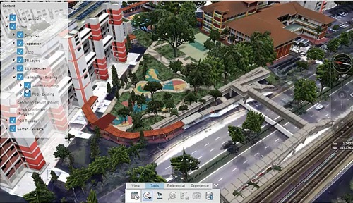
Virtual Singapore integrates various data sources including data from government agencies, 3D models, information from the Internet, and real time dynamic data from Internet of Things devices. The platform allows different agencies to share and review the plans and designs of the various projects in the same vicinity.
For example, Virtual Singapore makes it possible to visualise existing landscape against ongoing/future upgrading or renovation projects, which will enable agencies to collaborate to harmonise their respective projects and optimise the overall design and implementation. For example, pathways around the new amenities could be built to redirect human and traffic flow during the upgrading to minimise inconvenience to citizens.
In Virtual Yuhua, planners could visualise the various design options of a pedestrian overhead bridge and how it could be integrated seamlessly with the neighbourhood park that was being revamped as part of the Neighbourhood Upgrading Programme.
Communication and Visualisation
Virtual Singapore serves as a convenient platform for citizens to visualise upgrades to their estate, and allows them to provide timely feedback to the relevant agencies. For instance, the Yuhua estate is a test-bedding site for the Housing & Development Board’s Greenprint initiative, which features sustainable and green features such as solar panels, LED lights, pneumatic waste conveyance system, enhanced pedestrian networks and extended cycling networks. With the completion of Virtual Yuhua, it could be used to showcase the possibilities and benefits of the HDB Greenprint initiative in other estates.
Improved Accessibility
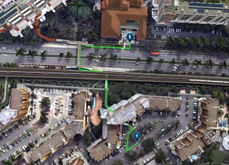
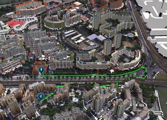
Virtual Singapore includes terrain attributes, for example, water bodies, vegetation and transportation infrastructure. This is different from conventional 2D maps that are not capable of showing terrain, curbs, stairs or steepness of a slope.
As an accurate representation of the physical landscape, Virtual Singapore can be used to identify and show barrier-free routes for the disabled and elderly. They can easily find the most accessible and convenient route, and even sheltered pathways, to the bus stop or MRT station. Public can also use Virtual Singapore to visualise park connectors and plan their cycling routes.
Urban Planning
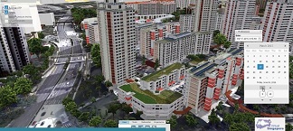
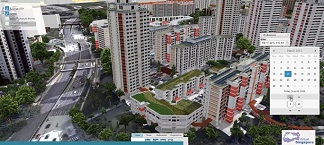
Virtual Singapore can provide insights into how ambient temperature and sunlight vary throughout the day. Urban planners can visualise the effects of constructing new buildings or installations, for example green roofs in the Yuhua estate, on the temperature and light intensity in the estate. Urban planners and engineers can also overlay heat and noise maps on Virtual Singapore for simulation and modelling. These can help planners to create a more comfortable and cooler living environment for residents.
Virtual Singapore also supports a semi-automated planning process where planners could quickly filter buildings of interest based on preset parameters. For example, when identifying HDB blocks suitable for installing solar panels under the HDB Greenprint initiative, urban planners can use Virtual Singapore to quickly filter the suitable blocks according to specified criteria like number of storeys and roof type.
Analysis on Potential for Solar Energy Production
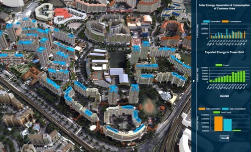
Data such as height of buildings, surface of the rooftops and amount of sunlight are available in Virtual Singapore. This allows urban planners to analyse which buildings have a higher potential for solar energy production, and hence more suitable for installation of solar panels.
Further analysis can allow planners to estimate how much solar energy can be generated on a typical day, as well as the energy and cost savings. Virtual Yuhua has demonstrated that by cross referencing with the historical data collected from neighbouring buildings, this analysis can be validated and seasonally adjusted to reflect an even more accurate and granular projection.
(Source: https://www.nrf.gov.sg/programmes/virtual-singapore)